Yellowhead
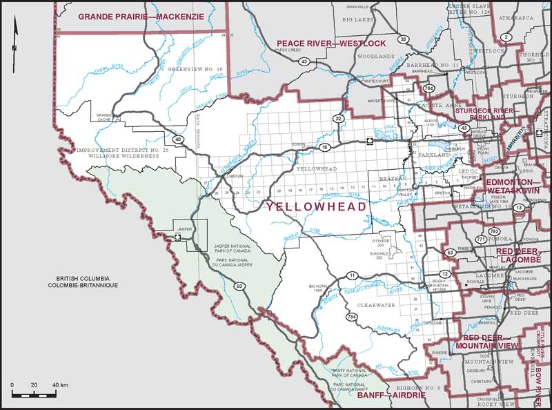
Boundaries description
Consisting of that part of the Province of Alberta described as follows: commencing at the intersection of the west boundary of said province with the north boundary of Tp 64; thence east along the north boundary of Tp 64 to the east boundary of R 24 W 5; thence south along the east boundary of R 24 W 5 to the northerly limit of Yellowhead County; thence generally easterly along said limit to the westerly limit of Lac Ste. Anne County; thence generally northerly, generally easterly and generally southerly along the westerly and northerly limits of said county to Highway No. 764; thence southerly along said highway to Highway No. 43; thence generally southeasterly along said highway to the northerly boundary of Alexis Indian Reserve No. 133; thence easterly and southerly along the northerly and easterly boundaries of said Indian reserve to Highway No. 43; thence generally southeasterly and southerly along said highway to the northerly limit of Parkland County; thence easterly along said limit to Range Road 20-Lake Eden Road; thence southerly along said road and Range Road 20 to Township Road 510; thence easterly along said road to the northerly production of Range Road 20; thence southerly along said production, Range Road 20 and its southerly production to the right bank of the North Saskatchewan River; thence generally southeasterly along said bank to the northerly production of Range Road 10; thence southerly along said production, Range Road 10 and its intermittent productions to Township Road 482; thence generally westerly along said road to Range Road 20; thence southerly along said road to Highway No. 616; thence westerly along said highway to Highway No. 771; thence southerly along said highway to Township Road 474; thence westerly along said road to Range Road 22; thence southerly along said road to the northerly limit of Wetaskiwin County No. 10; thence westerly along said limit to the easterly limit of Clearwater County; thence generally southerly, westerly and generally northwesterly along the easterly, southerly and westerly limits of said county to the southerly boundary of Jasper National Park of Canada; thence generally northwesterly and generally southwesterly along said boundary to the west boundary of the Province of Alberta; thence generally northwesterly and northerly along said boundary to the point of commencement.